OWETIS
In this project we address a new and very important issue: the observation of small backcountry wetland areas surrounded by different areas, hosting important species and delivering essential ecosystem services and biodiversity. Although these patches are small one by one, but together they can contribute to the wetland cover area with a very high rate – their protection and mapping is a need. These small ecosystems act a main role in the Hungarian biodiversity – these many small patches may give an important contribution to the ecosystem in the Carpathian basin.
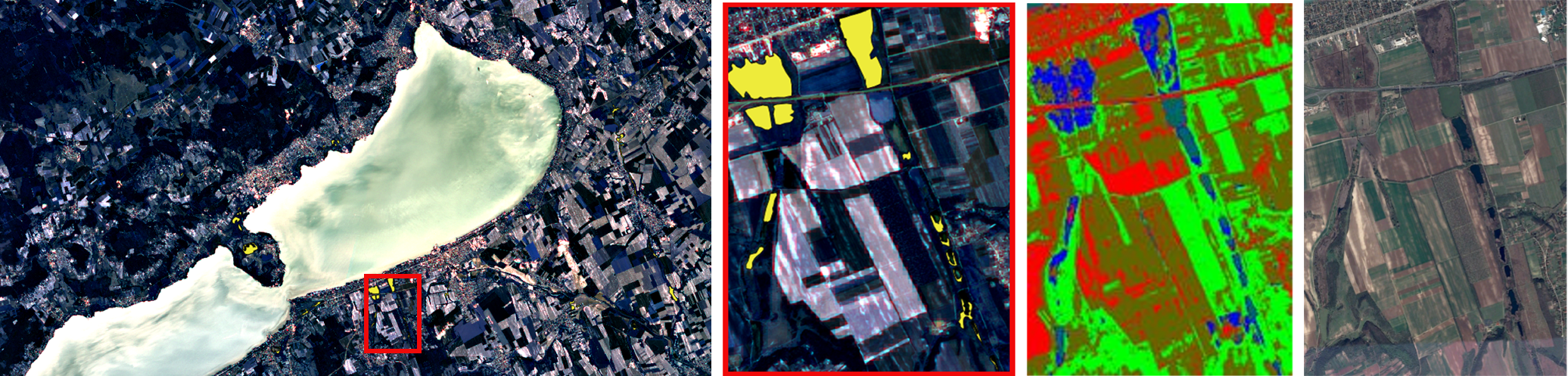
While large extensive wetlands, such as those on lake shores are in focus of monitoring and conservation, small patches of wetland vegetation in the mosaic of the landscape receive far less attention: in many cases their extent and location are not known precisely as they are smaller than the typical scale of regional vegetation mapping. Meanwhile, these small backcountry wetlands are especially important as they are often the last undisturbed habitats in landscapes extensively modified by agriculture and urbanization, and as such provide sanctuaries and “stepping stones” for wildlife sensitive to human presence. They also play an important role in regulating water quality and quantity through pollution absorption, groundwater recharge and flood retention. Therefore, backcountry wetlands are essential elements of green infrastructures.
Moreover, Hungary in the Carpathian basin has a special river and wetland structure, where we have remaining wetland habitat patches reduced from large continuous areas of the last centuries or maybe from ancient time when the whole basin was a great wetland area. The remaining great habitats function as natural reserve areas (Natura 2000 habitats), but the tracing and tracking of the small habitats should be the next important step in the protection of biodiversity in Hungary.
Small wetland patches are prone to rapid change depending on local water and management conditions, therefore up to date information is necessary for their assessment and protection.
Publications
A. Manno-Kovács, A. L. Majdik and T. Szirányi, " Satellite and Aerial Image Processing for Smart Farming and biodiversity Conservation", ERCIM News 113, pp. 33-34, April 2018.
M. Shadaydeh, A. Zlinszky, A. Manno-Kovacs, T. Sziranyi, "Wetland Mapping by Fusion of Airborne Laser Scanning and Multitemporal Multispectral Satellite Imagery", International Journal of Remote Sensing, vol. 38, no. 23, pp. 7422-7440, 2017.
- Balaton Limnological Institute, Centre for Ecological Research: Viktor Tóth, András Zlinszky
- Airbus DS Geo Hungary Kft: György Domokos